Geographical Position of the USA (1794)
the Gulf of Mexico ['g lfəv'meksikou] – Мексиканский залив
California [,kжli'fo:njə] – Калифорния
Appalachian Mountains [,жpe'leit∫jən 'mauntinz] — горы Аппалачи
Cordilleras [,ko:di’ljeərəz] – горы Кордильеры
the Rocky Mountains – Скалистые горы
Lake Superior ['leik sju'piəriə] – озеро Верхнее
Huron ['hjuərən] – озеро Гурон
Michigan ['mi∫igən] – озеро Мичиган
Erie ['iəri] – озеро Эри
Ontario [on'teəriou] – озеро Онтарио
St. Lawrence River [saint'lo:rəns] – p. Св. Лаврентия
the Mississippi [,misi'sipi] – p. Миссисипи
the Missouri [mi'zuəri] – p. Миссури
the Ohio [ou'haiou] – p. Огайо
the Niagara Falls [nai'жgərə'fo:lz] – Ниагарский водопад
the Colorado [,kolə'ra:dou] – p. Колорадо
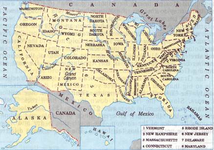 The USA is the fourth largest country in the world (after Russia, Canada and China). It is situated in the central and the southern parts of the North American continent and covers the territory of over nine million square kilometres, i.e. only little less than the area of Europe. The population of the country (according to 2000 census) is 280,562,489 people. It consists of 50 states and a federal district. The country is washed by the Atlantic Ocean in the east and by the Pacific Ocean in the west. It stretches from Canada in the north to Mexico, the Gulf of Mexico, and the Gulf of California in the south. It also has a sea-border with Russia. Its territory also includes the states of Alaska, in the north-west corner of North America, and Hawaii, in the mid-Pacific Ocean.
The USA is divided into three areas: Eastern area – highland with Appalachian Mountains, Central area – plain and Western mountainous area including the Cordilleras and the Rocky Mountains. Between the mountain ranges are the central lowlands, called the prairie, and the Eastern Lowlands, called the Mississippi Valley.
The north-eastern part of the USA is the region of the five Great Lakes – Lake Superior, Huron, Michigan, Erie and Ontario. The lakes are joined together by short rivers and canals and cut by rapids. The greatest of these rapids is the Niagara Falls. The waters of the five lakes have the outlet into the Atlantic Ocean by the St. Lawrence River. In the west of the USA there is another lake called the Great Salt Lake.
The greatest rivers of the USA are the Colorado and the Columbia flowing into the Pacific Ocean, the Mississippi with its tributaries – the Missouri and the Ohio – flowing into the Gulf of Mexico, and the Hudson River, which flows into the Atlantic Ocean. The rivers in the west are unsuitable for navigation as they are cut by deep rapids. They serve as a great source of electric power.
There different climatic zones on the territory of the USA. But on the whole the climate of the country is continental. Large reserves of coal, oil, gas, and iron ores, ferrous and non-ferrous metals form a solid base for the development of the USA industry.
***
Дата добавления: 2015-05-26; просмотров: 1661;