Milestones
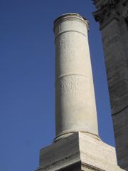
Miliarium (milestone) Potaissa Napoca Miliarium
After 124 BC most viae were divided into numbered miles by milestones. The words we translate as mile are milia passuum, “one thousand of paces”, which amounted to about 1620 yards, 1480 meters. A milestone, or miliarium, was a circular column on a solid rectangular base, set two feet into the ground, standing several feet high, 20" in diameter, weighing about 2 tons. At the base was inscribed the number of the mile relative to the road it was on. In a panel at eye-height was the distance to the Roman Forum and other information about the officials who made or repaired the road.
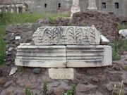
Remains of the miliarium aureum in the Roman Forum.
The Romans had a preference for standardization whenever they could, and so Augustus, after becoming permanent commissioner of roads in 20 BC, set up the golden milestone near the temple of Saturn. All roads were considered to begin from this gilded bronze monument. On it were listed all the major cities in the empire and distances to them. Constantine called it the navel of Rome.
Milestones permitted distances and locations to be known and recorded exactly. It wasn’t long before historians began to refer to the milestone at which an event occurred.
Way Stations
A legion on the march didn’t need a way station, as it brought its own baggage train and constructed its own camp (castra) every evening at the side of the road. Other officials or people on official business, however, had no legion at their service, and so the government maintained way stations, or mansiones (“staying places”), for their use. Passports were required for identification.
Carts could travel about 8 miles per day, pedestrians a little more, and so each mansio was about 15 to 18 miles from the next one. There the official traveller found a complete villa dedicated to his refreshment. Oftentimes a permanent military camp or a town grew up around the mansio.
Non-official travellers needed refreshment too, and at the same locations along the road. A private system of cauponae were placed near the mansiones. They performed the same functions but were somewhat disreputable, as they were frequented by thieves. Graffiti decorate the walls of the few whose ruins have been found.
Genteel travellers needed something better than cauponae. In the early days of the viae, when little unofficial existed, houses placed near the road were required by law to offer hospitality on demand. Frequented houses no doubt became the first tabernae, which were hostels, rather than the “taverns” we know today. As Rome grew, so did its tabernae, becoming more luxurious and acquiring good or bad reputations as the case may be. One of the best hotels was on the Via Appia. It had a large storage room containing barrels of wine, cheese and ham.
A third system of way stations serviced vehicles and animals: the mutationes (“changing stations”). They were located every 12-18 miles. In these complexes, the driver could purchase the services of wheelrights, cartwrights, and veterinarians. Using these stations in chariot relays, the emperor Tiberius hastened 500 miles in 24 hours to join his brother, Drusus Germanicus, who was dying of gangrene as a result of a fall from a horse.
Vehicles
Roman law and tradition forbade the use of vehicles in urban areas, except in certain cases. Married women and government officials on business could ride. The law restricted commercial carts to night-time access to the city within the walls and within a mile outside the walls. Outside the cities, Romans were avid riders and rode on or drove quite a number of vehicle types, some of which are mentioned here.
For purposes of description, Roman vehicles can be divided into the car, the coach and the cart. Cars were used to transport one or two individuals, coaches were used to transport parties, and carts to transport cargo.
Of the cars, the most popular was the currus (“car”), a standard chariot form descending to the Romans from a greater antiquity. The top was open, the front closed. One survives in the Vatican. It carried a driver and a passenger. A currus of two horses was a biga; of three horses, a triga; and of four horses a quadriga. The tyres were of iron. When not in use, its wheels were removed for easier storage.
A more luxurious version, the carpentum, transported women and officials. It had an arched overhead covering of cloth and was drawn by mules. A lighter version, the cisium, equivalent to our gig, was open above and in front and had a seat. Drawn by one or two mules or horses, it was used for cab work, the cab drivers being called cisiani.
The coach had 4 wheels. The high sides formed a sort of box in which seats were placed, with a notch on each side for entry. It carried several people with baggage up to the legal limit of 1000 pounds. It was drawn by teams of oxen, horses or mules. A cloth top could be put on for weather, in which case it resembled a covered wagon. It was probably the main vehicle for travel on the viae.
Of the carts, the main one was the plaustrum or plostrum. This was simply a platform of boards attached to wheels and a cross-tree. The wheels were solid and were several inches thick. The sides could be built up with boards or rails. A large wicker basket was sometimes placed on it. A two- and a four-wheel version existed.
The itinerary
The Romans and ancient travellers in general did not use maps. They may have existed as special items in some of the libraries, but they were hard to copy and were not in general use. On the Roman road system, however, the traveller needed some idea of where he was going, how to get there, and how long it would take. The itinerary filled this need. In origin it was simply a list of cities along a road. It was only a short step from lists to a master list. To sort out the lists, the Romans drew diagrams of parallel lines showing the branches of the roads. Parts of these were copied and sold on the streets. The very best featured symbols for cities, way stations, water courses, and so on. They cannot be considered maps, as they did not represent landforms.
The Roman government from time to time undertook to produce a master itinerary of all Roman roads. Julius Caesar and Mark Antony commissioned the first known such effort in 44 BC. Zenodoxus, Theodotus and Polyclitus, three Greek geographers, were hired to survey the system and compile a master itinerary. This task required over 25 years. The result was a stone engraved master itinerarium set up near the Pantheon, from which travelers and itinerary sellers could make copies.
Дата добавления: 2015-06-05; просмотров: 954;