Algorithm helps define final 3D seismic survey polygon
The design of а 3D seismic survey depends on a number of field parameters that control the patch geometry and layout of source and receiver lines.
A 3D seismic survey is planned over a subsurface geologic target area, usually picked from interpreted 2D migrated seismic data. Due to the presence of dips, this migrated subsurface area is expanded into immigrated surface area, which in turn is further expanded into the. Final survey area, in order to get full fold coverage over the target area.
In most cases, except star and radial layouts, the initial design starts with source and receiver lines in the form of a rectangular grid, which is interactively clipped at the edges according to the shape of the expanded geologic target area.
Several software applications are available with a whole range of 3D survey design and analysis capabilities, but they do not provide an automated procedure for geologic target area expansion and clipping of source and receiver lines within the final survey boundary.
This article presents an algorithm for expanding the subsurface geologic target area polygon into the final survey area polygon, on the basis of migration aperture and fold taper zone and finally, clipping the source and receiver lines within this expanded survey area polygon. The working of the algorithm is demonstrated through a practical example.
Field development
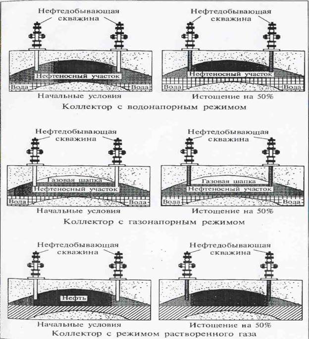
Once a commercially productive well has been drilled, proving the existence of an oil field, interest turns to the problem of determining how large the field is. The productive area must be determined, and the more productive sections must be located.
Once a given area is designated as productive, the operator within that area begins planning a development program that will protect his property from neighboring operators and that will provide the maximum economic return to the owner. One way the operator does this is to be sure the landman has done his homework and has leased as many adjacent properties is possible. Usually, though, many different operators own portions of a field and compete for production. Therefore , the location of initial wells in undeveloped areas is influenced by property lines as well as geologic structures. Protecting these property lines is a great consideration. More about this shortly.
Even though competent geological advice may be available, the early period of development of a field is uncertain. If a number of operators are competing with each other, the emphasis will be on speed of drilling to develop early production instead of securing accurate well data to help correlate and interpret the structure. Many operators consider their well logs confidential information. In these cases, it becomes difficult for operators to determine the structural and stratigraphic relationships – information fundamental in planning a development program.
When planning a program, several characteristics are very important to remember. When the natural reservoir energy is utilized to its full potential, the reservoir will produce more efficiently and economically. Early wells experience higher reservoir pressure and greater production time, so their initial and ultimate production is substantially greater than wells drilled later. A delay of even a few months may mean substantial losses in ultimate production.
Another important aspect of timeliness deals with obtaining more oil than a neighboring property. The operator who first brings this property to full development can secure more of his neighbor’s oil. Oil and gas migration doesn’t stop at the property line; they move to the nearest well. Theoretically, the first wells drilled have greater ultimate productions if completed in the best part of the section, Initial production will be greater again because of the higher gas pressure during the early stages of development. So the “first come, first served” policy is an important factor. It all boils down to timeliness.
Information gained from drilling the first well is integrated with previous information (logs, maps, and pressure and production data) to determine the extent of the field and its estimated recoverable reserves of oil and gas. Then a development plan is formulated, witch considers the total number of wells required, the spacing or distance between the wells, and the geometric pattern for placing the wells.
Дата добавления: 2015-11-20; просмотров: 994;